Aquatic Resources Banner Image
Programs

Aquatic Resources


Riparian and wetland areas, lakes, streams, and aquifers on public lands managed by the Bureau of Land Management (BLM) are among the most important, productive, and diverse resources in the Nation, providing sustained value to the American public. They provide habitat for myriad species of plants, fish, and wildlife; provide ecosystem services such as drinking water, pollination, and nutrient cycling; attenuate effects of wildfires, floods, and drought; and are key to the vitality of local economies and communities.

Aquatic resources also support permitted activities on public lands such as livestock grazing, energy and mineral development, timber production, and countless recreation opportunities. The BLM's Aquatic Resources Program works with BLM managers, tribal, federal, state and local governments and non-governmental partners to ensure the long-term sustainability of aquatic resources for the use and enjoyment of present and future generations.

NOTE: Materials available from these pages are contributed by BLM staff. Expect the collection to continue growing in time to reflect the most current information available. 

Freshwater habitats, resources, and species are declining at unprecedented rates. Chief among the drivers are water development and climate change. Dams, diversions, and groundwater extraction disconnect and degrade riparian and fisheries habitat and deplete water supplies. Climate change affects all aspects of the hydrologic cycle. Hydrologic stress resulting from climate change alters the timing, frequency, duration, and magnitude of events such as drought, floods, and wildfire; alters the thermal regime of freshwater habitats; exacerbates resource use impacts; and threatens to undermine restoration actions. Drought and wildfire exacerbated by climate change have the potential to adversely impact multiple BLM programs by reducing the availability of water and vegetation. Interacting with these threats are challenges related to invasive species, pollution, and current and past permitted and legacy uses on public lands.

As the largest land management agency in the U.S., the BLM has a critical role to play in ensuring the health and sustainability of riparian, fisheries, and water resources and their resistance, resilience, and adaptability to combat climate change. The BLM must focus on management efforts that conserve remaining high-quality lands and waters; restore degraded riparian, fisheries, and water resources; and ensure the connectivity of these systems.

Mission

Conserve and restore riparian, fisheries, and water resources to provide resource values and ecosystem services necessary to achieve the BLM’s multiple use and sustained yield mandate.

Vision statement

Create an interdisciplinary program that is a leader in the conservation and restoration of riparian, fisheries, and water resources for the benefit of all Americans.

Our Aquatic Resources Strategic Plan shares priorities through 2026

Do not be afraid to ask questions. Should you ever need any assistance, there are numerous specialists willing to help answer questions.

Here are the BLM's Aquatic Resource Program Leads and their relevant specialties:


Aquatic Resources


Primary Contacts

Office

Fisheries

Riparian

Water/Hydrology

AK

Matt Varner
mvarner@blm.gov
Matt Varner
mvarner@blm.gov
Ben Stratton
btstratton@blm.gov

AZ

Codey Carter
cdcarter@blm.gov
Aaron Wilkerson
awilkers@blm.gov
Aaron Wilkerson
awilkers@blm.gov

CA

Sam Flanagan
(Acting)
sflanaga@blm.gov
Sam Flanagan
(Acting)
sflanaga@blm.gov
David B. O'Connor

doconnor@blm.gov

CO

Tom Fresques
t1fresqu@blm.gov
Tom Fresques
t1fresqu@blm.gov
Ed Rumbold
erumbold@blm.gov

ES

Annie Ebbers (A)
aebbers@blm.gov
Annie Ebbers (A)
aebbers@blm.gov
Annie Ebbers (A)
aebbers@blm.gov

ID

Ethan Ellsworth
eellsworth@blm.gov
Ethan Ellsworth
eellsworth@blm.gov
Ethan Ellsworth
eellsworth@blm.gov

MT/DK

Amy Waring (A)
awaring@blm.gov
Amy Waring (A)
awaring@blm.gov
Amy Waring (A)
awaring@blm.gov

NV

Quinn Young
qyoung@blm.gov
Nicole Cutler (A)
ncutler@blm.gov
Nicole Cutler (A)
ncutler@blm.gov

NM

Keith Sauter
ksauter@blm.gov
Keith Sauter
ksauter@blm.gov
Keith Sauter
ksauter@blm.gov

OR/WA

Emily Johnson
ekjohnson@blm.gov
Stephanie Messerle
smesserl@blm.gov
Mike Brown
mebrown@blm.gov

UT

Cassie Mellon
cmellon@blm.gov
Cassie Mellon
cmellon@blm.gov
Jared Dalebout
jdalebou@blm.gov

WY

Chris Keefe
ckeefe@blm.gov
Chad Mickschl
cmickschl@blm.gov
Chad Mickschl
cmickschl@blm.gov

HQ

Sharmila Premdas Jepsen
sjepsen@blm.gov
Melissa Dickard
mdickard@blm.gov
Paula Cutillo
pcutillo@blm.gov

HQ

Aquatic Program Lead: Scott Miller
swmiller@blm.gov 


Drought & Water Availability Assessment Guidelines 

The Drought and & Water Availability assessment guidelines will assist BLM Offices in determining if drought and/or water availability are issues or concerns that will be analyzed further in the NEPA process for planning or implementation actions. 

Drought Assessment Information

The BLM in collaboration with the Desert Research Institute (DRI) has developed web-based assessment tools that allow users to quickly process hydrologic, satellite, and climate data and to create maps and reports to track drought severity over time on BLM-managed lands.

Water Availability Assessment Information

BLM POLICY

TRAINING

EMERGING ISSUES

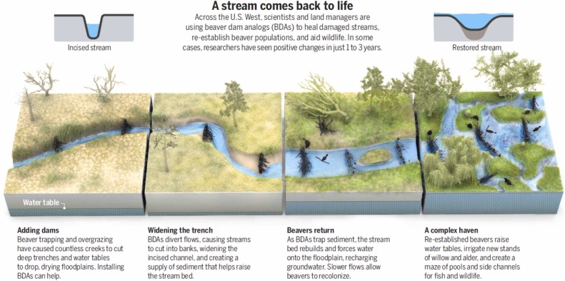
As the single largest federal land manager, the Bureau of Land Management (BLM) has a critical role to play addressing three inter-related crises: drought, wildfire, and habitat loss. Key to addressing these challenges is the protection and restoration of freshwater resources, including riverscapes. The riverscapes concept is increasingly used to describe the interconnected systems that include streams and rivers and the connected floodplain, channel habitats, and shallow aquifers that make up valley bottoms, which are critical natural infrastructure and disproportionately valuable parts of the landscape. Riparian areas, the transition between upland and aquatic habitat, are important components of riverscapes and this broader concept recognizes that space, structure and complexity, resilience, and slowing water movement are also important to maintaining healthy streams. When healthy, riverscapes filter water pollution, support habitat for fish and other wildlife, form natural firebreaks, buffer the effects of drought and flood on communities and ecosystems, and support BLM’s overall multiple use and sustained yield mission. However, many riverscapes have been adversely impacted by historic and current uses and no longer provide the scope and scale of desired ecosystem services.

Goldfarb, 2018

Given these factors, the need for restoration often exceeds available resources. Managers must prioritize project opportunities (e.g. select the right streams & treatment methods) that will produce the greatest returns on restoration investments and ensure restoration actions achieve desired outcomes. To assist, the BLM has partnered with Utah State University (USU) and the Riverscapes Consortium (RC) to produce corresponding data, analysis tools, workflows, training materials, a community engagement platform, and data exchange that practitioners can use to plan, design, implement, and track riverscape restoration efforts across all lands in the Western U.S. Additional descriptions of tools and resources, such as a quick-start guide, are available on the BLM’s aquatic resources website, which will be added to as additional resources become available.

Restoration Design Manual and Related Training

  • The Low-Tech Process Based Restoration of Riverscapes Design Manual is a valuable resource for planning, designing, and implementing process-based restoration projects.
  • USU hosts formal training on project planning, design, and adaptive management, explaining many concepts from the above manual. These modules can also be taken through USU for formal credit in DOI Talent. Search “LTPBR” under “find learning” for these links.

Data Resources and Support

  • The RC has produced an array of decision-support tools that incorporate and/or produce data with different spatial extents and spatiotemporal resolutions to help practitioners answer questions that are specific to each of the spatial scales of planning.
  • Riverscape Viewer allows for the visualization of geospatial data related to riverscapes health. The viewer also exposes non-GIS data, like reports, json, tabular data, xml, imagery, PDFs, databases and more.
  • Riverscape Studio for QGIS (QRiS—pronounced curious) is a plug-in for monitoring riverscape health, designing projects, tracking outcomes, and providing information helpful for the permitting process. QGIS provides a flexible, extensible structure for riverscape project data, together with consistent symbology to streamline analysis, planning, and reporting. It was selected by our partners because it is free, open-source software and is available to students, academics and smaller non-profits who might be engaged in riverscape restoration. However, it will not be made available through Citrix or MS Azure GBP. The application is foundational for riverscape restoration projects as this functionality is not currently available in ArcPro+ or other software systems, and the associated data will answer local and state-level project questions while streamlining national reporting. The use of QGIS has been formally approved within DOI and the BLM for installation and use on government computers and is installed through a REMEDY ticket for IT. It may be helpful to coordinate with the state GIS Manager prior to requesting an install so that they are aware of the upcoming request. BLM GIS staff are not trained in QGIS or available to support this system; thus support will be achieved through the offices hours and help line described below.
  • To assist with any Riverscapes questions, USU is hosting office hours through their Riverscapes Application Support Specialists. They can assist with any questions or problems with the Riverscape Consortium tools and datasets or planning, designing, and implementing LTPBR projects.‪‪If you are unable to attend office hours, need immediate support, want to report a bug, or chat with the development team, staff can Submit a Ticket. The RC will review the request, route it to the appropriate application support specialist, and respond accordingly.
  • Knowledge Base: Explore “How-To’s,” RC supported apps, and documented solutions to common problems.

SPP Content

The science within the SPP science relies on YOU, the field biologist. As professional managers of wildlife you will often develop or follow science-based protocols based on studies conducted in your area. To best assists fellow and future BLM biologists, it is imperative you upload those science-based documents related to research conducted in your area.

To maximize the benefit of submissions, BLM staff are encouraged to submit scientific information that includes:

  • Research conducted on BLM Lands - this includes final reports from BLM staff or contracted entities.
  • Science syntheses and white papers
  • Examples of issue-based analysis for inclusion in NEPA
  • Scientifically informed best management practices
  • Bibliographies and annotated bibliographies
  • Links to key data sets
  • Links to key information portals (outside of the SPP)

To increase functionality and effectiveness of the SPP, items NOT encouraged for submission include:

  • Non-science related items (opinion pieces, news stories)
  • BLM Policy – Code of Federal Regulations, Executive Orders, Secretary Orders, Manuals, Handbooks, Instruction Memoranda, Information Bulletins
  • Generic or other types of scientific information with limited application to BLM management
  • Scientific information that has only very narrow geographic implications that would be unlikely to be useful across the agency
  • Peer-reviewed scientific journal articles that are available at the BLM library

When uploading content to the SPP, you will be asked to identify the most appropriate BLM program as this will route the uploaded content to the content manager for approval. Approval of content will be based on the Principles and Practices of Integrating Science Guidelines as described in IM 2017-030.

To find uploaded content, simply use the Advanced Search Function at the top of the page and use specific key words to narrow down your search options.

RESOURCES FOR THE AQUATIC RESOURCES SPECIALIST:

We understand that not every specialist knows where to find the Policy & Regs and Training they need to best execute their job. The following links will help find those resources specific to being a BLM aquatic specialist.

POLICY & REGULATIONS

The following links go directly to existing BLM pages. These are provided to the field biologists as a quick link for reference only. DO NOT upload any policy or regulations to the SPP. 

BLM Aquatics Policy - All policy and regulations relevant to BLM

BLM Manuals - most used by the Aquatics Program

BLM Handbooks - useful for riparian issues and vegetation management 

TRAINING

OTHER INFORMATION