
HAF Implementation Resources

HAF Technical Reference 6710-01
Cover of HAF TR

The four landscape scales for assessment described in the HAF TR are listed below. Mid- and fine-scales are to be completed by BLM Interdisciplinary Teams (IDTs) led by BLM state offices in coordination with district and field offices. Site-scale assessments are to be led by district and field offices in coordination with their state office:

  • Broad-scale (first-order) is defined by the pre-settlement habitat potential for Greater Sage-grouse and Gunnison sage-grouse.
  • Mid-scale (second-order) areas are linked to bird dispersal capabilities in subpopulation and population areas defined by indicators of landscape pattern.
  • Fine-scale (third-order) areas encompass the seasonal habitats within the home ranges of sage-grouse.
  • Site-scale (fourth-order) areas of seasonal habitats assess the more detailed vegetation indicators of seasonal habitat.

The BLM has operationalized the HAF TR with generalized processes, spreadsheet and report templates, and spatial tools to help state, district, and field offices complete mid-, fine-, and site-scale assessments by end of FY2024 (IM 2022-056). Check out the tabs below for HAF resources
Contact Us with any questions

Patches 2023

HAF Boundaries and Delineation

  • If updates or new boundaries are needed, check out the Guidelines for HAF Boundary Delineation
  • Download HAF Boundaries
    • HAF mid- and fine-scale boundaries are here: ...GBP\OC\projects\wildlife\SageGrouse\HAF\WestwideData\InputData\Boundaries.gdb\WW_HAF_Boundaries_Current  The layers are complete but will be updated as necessary changes are made. Check the metadata for publication dates and an explanation of changes from previous versions. Check with your sage-grouse lead or geospatial ecologist to confirm fine-scale boundaries in your state. (Updated December 2024)
    • HAF Mid-scale Boundaries IPOW 2020 version - (current as of January 31, 2019) this layer represents the boundaries used in the IPOW/TPOW process for the 2020 Program of Work. If you are working on project prioritization, funding allocation and/or the IPOW Guidebook for 2020 projects, use these boundaries.

Assessment Folder Location

All habitat assessment reports and associated data, regardless of analysis area, will be stored in a standardized format within the designated and centralized HAF folder (IM 2022-056). The HAF folder is on the network here: ...GBP\OC\projects\wildlife\SageGrouse\

Assessments will be stored in the ...\HAF\Assessments folder using a hierarchical structure that reflects the spatial scale of assessments. That is,

  • Mid-scale assessments are stored here ...\HAF\Assessments\MidScales\[your mid-scale name]
  • Fine-scale assessments are stored here ...\HAF\Assessments\MidScales\[your mid-scale name]\FineScales\[your fine-scale name]
  • Site-scale assessments are stored here ...\HAF\Assessments\MidScales\[your mid-scale name]\FineScales\[your fine-scale name]\SiteScales

Folder Structure

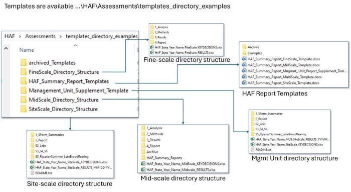
Directory structures are provided to facilitate standardization of HAF assessment analysis and reporting to comply with the HAF IM. When planning your HAF assessment you can copy and paste this structure to your assessment folder (described above). Directory structures are stored here: ...\HAF\Assessments\templates_directory_examples\

Templates are available for key decisions spreadsheets, results spreadsheets, and HAF reports for each scale, and for multiscale reports. The graphic (below) shows the location of templates in the HAF folder and these are the most recent templates; they are no longer available online.  

Key Decisions Spreadsheets - these spreadsheets will help you prepare for conducting mid-, fine- and site-scale assessments by listing key decisions that the ID team will need to make before an assessment is conducted. These are a great source of documentation for your summary report.

Results Spreadsheets - these spreadsheets help you produce and organize results in a standard format for the ID team to review. These are also a great source of documentation for your summary report.

Report Templates - use these templates to help you complete standard HAF reports as described in the HAF Technical Reference. Note that the templates represents the minimum content you should provide in a report. You are encouraged to add attachments, appendices, etc. to support your report. 

Use the multiscale report template to create a complete multi-scale assessment including one mid-scale, and the fine-scales and site-scales within the mid-scale.  

If you prefer to separate reports for each scale, templates for stand-alone mid-scale, fine-scale, site-scale, and management unit or allotment reports are available. Standalone reports can be nested within the multiscale report as needed.

Image removed.

Tools - network locations and user guides

  • All HAF tools and user guides are stored in this folder: ...\GBP\OC\projects\wildlife\SageGrouse\HAF\Tools
  • ArcGIS toolboxes and user-guides are available and are currently to be used on Citrix Zen Desktop ArcGIS Pro 3.1. Mid and fine-scale tools are in Python toolboxes (.pyt file extension) and require xml files to document in-tool help, hence the additional files. Tool files and user guides required for each scale are listed below.
  • Site-scale:
    • HAF_SiteScale_Tools_ArcPro.tbx, 
    • HAF_SiteScale_Tools_ArcPro_UserManual_V1.3.docx, 
    • HAF_SiteScale_Benchmarks_Appendix.docx
  • Fine-Scale: 
    • FineScaleHAFTools_Pro3.pyt, FS_tools.py, and 4 xml files (FIneScaleHAFTools_Pro3.FXxxxxxxx.pyt.xml where xx's relate to the individual tools).
    • HAF Mid and Fine Scale User Guide PRO3.pdf
    • These files are zipped in FineScaleTools.zip.
  • Mid-Scale: 
    • MidScaleHAFTools_Beta22Dec2023.pyt, MS_tools.py, and 7 xml files ( MidScaleHAFTools_Beta22Dec2023.Mxxxxx.pyt.xml where xx's relate to the individual tools e.g. MidScaleHAFTools_Beta22Dec2023.M1HabitatAvailability.pyt.xml). 
    • HAF Mid and Fine Scale User Guide PRO3.pdf
    • These files are zipped in MidScaleTools.zip.
    • These tools will move to released from beta when tested thoroughly and the file names will simplify then.

Patches 2023

  • Delineation of Greater Sage-Grouse Habitat Patches for use in the BLM Sage-grouse Habitat Assessment Framework (2023). This document describes the updated methods used to delineate habitat patches for Greater Sage-Grouse derived from work by Wann et al (2022).
    • The new patches will be used in the mid-scale tools.
    • This document replaces the Guidelines for Identifying Habitat Patches for BLM Sage-grouse Habitat Assessments (2018).
  • Obtain the new patches for your mid-scale assessment and import them into your mid-scale assessment folder (...\1_Analysis (See Folder Structure above).
    • Patch data are stored here: ...GBP\OC\projects\wildlife\SageGrouse\HAF\WestwideData\InputData\Patches2.gdb 
    • Find the patches for your mid-scale by name: "yourMid-scaleName_P2_x" (e.g., Baker_P2_1, Custer_P2_2) 
    • As patches are updated the numbers will change; check the metadata for information on changes
    • Run the tool:  "M2 Patch Size and Number" to create "M2_P2_Patches_InMidScale"
    • The new patch file "M2_P2_Patches_InMidScale", found in \Results\M2\, must be used in tools M3, M4, M5 because M2 created the occupy field in the attribute table.
    • See the mid-scale user guide for more details

Click here for Sage-grouse and Sagebrush related internal and external resources