
The Central Yukon REA was initiated in August 2013 with work scheduled to begin in September 2013. The Pre-assessment phase is scheduled to be completed by mid-2014. Task 1 (initiation of the project and development of a pre-workplan) will be completed by the end of 2013. The results of this Pre-assessment will be used to identify the scope of any subsequent assessment phases. See the Memos and Reports section for a list of scheduled tasks and to download the completed documents when they become available.
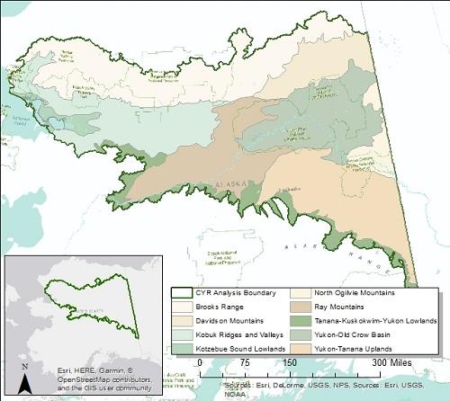
The Central Yukon REA in central Alaska encompasses the Kobuk Ridges and Valleys ecoregion, the Ray Mountains ecoregion, and all areas of the Brook Range ecoregion from the crest of the range southward.
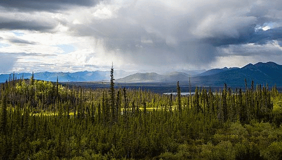
The Kobuk Ridges and Valleys is a series of paralleling ridges and valleys. This diagnostic feature is created in part by high-angle reverse faults and interceding troughs. This area was overridden by past ice sheets descending from the north. Today, immense U-shaped valleys harbor large rivers that originate in the Brooks Range. The broad valleys are lined with alluvial and glacial sediments whereas the intervening ridges are covered with rubble. Thin to moderately thick permafrost underlies most of the area. A dry continental climate prevails with long cold winters and short cool summers. Frigid conditions are reinforced during the winter as the valleys serve as cold-air drainages for the Brooks Range. Forests and woodlands dominate much of the valley bottoms and mountainsides with black spruce in wetland bogs, white spruce and balsam poplar along rivers, and white spruce, white birch, and trembling aspen on well-drained uplands. Tall and short shrublands of willow, birch, and alder communities occur on ridges. Trees become increasingly sparse, less robust, and restricted to lower elevations in the west.
The Ray Mountains are an overlapping series of compact, east-west trending ranges. The metamorphic bedrock is usually covered with rubble, and soils are subsequently shallow and rocky. The area was largely unglaciated during Pleistocene ice ages, except for alpine glaciers that capped the highest peaks. Permafrost is generally discontinuous and ranges from thin to moderate thickness. The climate is strongly continental with dry, cold winters and somewhat moist, warm summers. The vegetation is dominated by black spruce woodlands, while white spruce, birch, and aspen usually are restricted to warm, south-facing slopes. Floodplains are dominated by white spruce, balsam poplar, alders, and willows. Shrub birch and Dryas-lichen tundra prevail at higher elevations. Forest fires occasionally occur in the summer. The clear headwater streams are important habitat for arctic grayling and of minor importance to king, chum, and coho salmon. Moose, brown bears, wolves, red fox, lynx, and marten are common land dwellers.
The Brooks Range is an east-west trending range and represents the northern extension of the Rocky Mountains. The high central portion possesses steep angular summits of sedimentary and metamorphic rock draped with rubble and scree. To the west and east, the topography becomes less rugged – for instance the Richardson Mountains have flat-topped summits flanked by stepped slopes reflecting bedrock conditions. High-energy streams and rivers cut through narrow ravines with steep headwalls etching a deeply-incised, dendritic pattern into the terrain. During the Pleistocene Epoch, mountain glaciers coalesced to cover the higher portions of the range – here only a few remnants in the form of small cirque glaciers still exist. The Richardson Mountains were ice-free during the last ice age and blocked the continental ice sheet advance from the east. The dry polar climate has short, cool summers and long, cold winters; and air temperatures decrease rapidly with rising elevation. Alpine tundra and barrens dominate at higher elevations along the entire crest of the range. On the south side, lower mountain slopes and valleys possess sedge tussocks and shrubs. The arctic tree line skirts across the range in Canada and is restricted to the south side of the range in Alaska. Here, sparse conifer-birch forests and tall shrublands occur in larger valleys. Dall sheep, gray wolves, brown bears, marmots, and caribou inhabit the mountains. Arctic grayling are found in groundwater fed springs and streams.
Management questions guide an ecoregional assessment. Management questions address specific information needs in order to produce meaningful information for future management actions. Management questions for the Central Yukon ecoregions will likely encompass these nine broad themes:
-
Native Plant Communities
-
Aquatic Resources
-
Wildlife Resources
-
Climate and Permafrost
-
Fire
-
Invasive Species
-
Energy Development and Mining
-
Regional Socioeconomics
-
Subsistence
The management questions for the Central Yukon REA will be presented in the Task 1 Final Memorandum.
Conservation elements are renewable resources of high conservation interest within an ecoregion. The Central Yukon REA will assess the current condition and forecasted future condition of the predominant terrestrial and aquatic ecosystems and species of regional concern within two broad categories:
-
“Coarse-filter” conservation elements, which typically include all of the major ecosystem types within the assessment landscape, and represent all of the predominant natural ecosystem functions and services in the ecoregions;
-
and “Fine-filter” conservation elements, which complement the first set of elements by including a limited subset of focal species assemblages and individual species.
A full list and explanation of the conservation elements will be included in the Task 1 Final Memorandum.
A key purpose of this REA is to understand the influences of features or phenomena that have the potential to affect the size, condition and landscape context of conservation elements present in the Central Yukon ecoregions. These change agents are likely to be included in the assessment:
-
Climate change
-
Fire
-
Invasive species
-
Development
A more complete discussion of the change agents will be included in the Task 1 Final Memorandum.
Geospatial data, maps, and models used in and produced by the REAs will be made available to the public upon final completion of each individual assessment.
For each REA, there is a series of memos which are supplemental documents to the final report. Memos document the major tasks and decision points made during the assessments and provide pertinent background information necessary to understand the justification and methods used during the assessment. As memos and the final report are completed, they can be downloaded through the table below.
Central Yukon (CYR) REA Memos and Reports
| Description | Document Link |
|---|---|
Management questions, conservation elements, and change agents |
Task 1 - Final Memo & Appendices |
Analytical models and tools This is a combined memo with Datasets for analysis |
Memorandum II Data Methods |
REA work plan |
Workplan CYR Final |
Preliminary findings for review |
Draft Distribution Models Webinar for Anthropogenic CAs (video) Draft Distribution Models Webinar for Aquatic CEs (video) Draft Distribution Models Webinar for Biotic CAs (video) Draft Distribution Models Webinar for Terrestrial Coarse Filter CEs (video) Draft Distribution Models Webinar for Terrestrial Fine Filter CEs (video) |
REA Land Status Map |
CYR Land Status Map CYR Land Status Online Map |