
The Seward Peninsula REA was initiated in September 2010. It has been completed and peer reviewed and is now available to the public. The Memos and Reports section provides access to the REA data for this ecoregion.
The Seward Peninsula REA is comprised of three ecoregions: the Seward Peninsula, the Nulato Hills, and the Kotzebue Sound Lowlands (SNK). These three ecoregions’ climate is classified as moist polar. At this latitude, ice spans the sea early every winter, allowing direct passage of cold Siberian air. Persistent cold, windy conditions occur in the winter and fog blankets the coastlines in the summer. Vegetation is generally tundra on the peninsula (alpine Dryas-lichen tundra and barrens at high elevations) and moist sedge-tussock tundra in the lowlands with patches of low-growing ericaceous and willow-birch shrubs on better-drained areas. In the hills, vegetation patterns generally follow the terrain, with Dryas-lichen and sedge-ericaceous shrub tundra on hilltops, grading into willow-birch-alder shrublands and eventually spruce and birch woodlands at lower elevations. Moose, brown bears, caribou, arctic foxes, and Alaska hares are common in all of these ecoregions. Ribbon seals and walruses comb the coastline, and huge summer runs of pink salmon ascend the Unalakleet drainage.
The Nulato Hills are the remains of an ancient mountain range after extended periods of down cutting, weathering, and erosion. East of Norton Sound, these hills ripple inland in a southwest-northeast orientation with streams flowing in intervening valleys. Due to their modest elevation, most of these hills have been spared from recent glaciations and were part of the ice-free Beringia corridor linking North America and Asia.
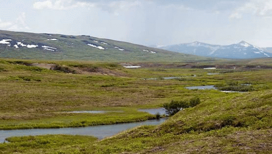
The Seward Peninsula is a cold, wind-swept landmass jutting out into the Bering Sea and represents the southernmost haunt of polar bears on mainland Alaska. It is a landscape mosaic of coastal lowlands, expansive convex hills with scattered broad valleys, and small, isolated groups of rugged mountains. Permafrost is continuous and soils are therefore often wet, shallow, and organic. Ice-related features such as pingos and patterned ground are present. Dense concentrations of lakes and ponds support abundant waterfowl and nesting birds on the coastal plains. At its height, Pleistocene glaciation covered only the highest mountains and the peninsula was also part of the ice-free migration corridor between North America and Asia.
These ecoregions have strong ecological affinities to Asia that remain to this day with the presence of Eurasian birds (gray-headed chickadee, yellow and white wagtails, bluethroat), fishes (Alaska blackfish), and flora.
Ecoregion descriptions were excerpted and modified from “Ecoregions of Alaska,” Nowacki et al. 2000.

The ecoregional assessment is driven and guided by management questions. These questions address specific information needs that produce meaningful information for future management actions. Management questions for the Seward Peninsula REA are based upon 10 broad themes:
-
Native Plant Communities
-
Aquatic Resources
-
Species
-
Climate and Permafrost
-
Fire
-
Invasive Species
-
Reindeer Grazing
-
Development
-
Regional Socioeconomics
-
Subsistence
The management questions for the Seward Peninsula REA are presented in the Task 1 Final Memorandum.
Conservation elements are renewable resources of high conservation interest within an ecoregion. This REA assessed the current condition and forecasted future condition of two types of conservation elements:
-
“Coarse-filter” conservation elements, which typically include all of the major ecosystem types within the assessment landscape, and represent all of the predominant natural ecosystem functions and services in the ecoregions;
-
and “Fine-filter” conservation elements, which complement the first set of elements by including a limited subset of focal species assemblages and individual species.
Conservation elements for the Seward Peninsula REA include 32 terrestrial and aquatic ecological systems occurring in the ecoregions as well as 24 individual species of regional/landscape concern, 39 local species, and 3 species assemblages. A full list and explanation of the conservation elements can be found in the Seward Peninsula Task 1 Final Memorandum.
A key purpose of this REA is to understand the influences of significant, widespread change agents on the natural resources of the Seward Peninsula, the Nulato Hills, and the Kotzebue Lowlands ecoregions. Change agents are those features or phenomena that have the potential to affect the size, condition, and landscape context of conservation elements. Change agents in the Seward Peninsula REA landscape are:
-
Climate change
-
Fire
-
Invasive species
-
Development
A more complete discussion of change agents is presented in the Task 1 Final Memorandum.
Geospatial data, maps, and models used in and produced by the REAs will be made available to the public upon final completion of each individual assessment.
In some instances, data may be released in phases for an REA to expedite public access to particular data sets. To learn more about REA data products and determine which REAs have available data, go to the REA Data Portal.
For each REA, there is a series of memos which are supplemental documents to the final report. Memos document the major tasks and decision points made during the assessments and provide pertinent background information necessary to understand the justification and methods used during the assessment. As memos and the final report are completed, they can be downloaded through the table below.
Seward Peninsula (SNK) REA Memos and Reports
| Description | Document Link |
|---|---|
Management questions, conservation elements, and change agents |
Task 1 Final Memorandum |
Datasets for analysis |
Task 2 Final Memorandum |
Analytical models and tools |
Task 3 Final Memorandum |
REA work plan |
Task 4 Final Workplan |
REA Final Report |
REA Final Report 3/5/2014 Appendices A-F |
REA Land Status Map |
Land Status Map |