
MONITORING FOR ADAPTIVE MANAGEMENT
AIM-Monitoring: A National, Integrated Monitoring Approach
Using its “Assessment, Inventory, and Monitoring Strategy” (AIM Strategy) for resource monitoring, the BLM is more efficiently and effectively able to meet local, regional, and national information needs. The AIM Strategy provides a process for the BLM to collect quantitative data on the status, condition, trend, amount, location, and spatial pattern of renewable resources on the nation’s public lands. This data serves many monitoring objectives and is easily aggregated for use at multiple scales—from individual field offices to public lands across the Western U.S. and Alaska. Each AIM-Monitoring survey uses a set of core indicators, standardized field methods, remote sensing, and a probability-based sample design to provide nationally consistent and scientifically defensible information to track changes on public lands over time.
The BLM uses information derived from AIM-Monitoring to make necessary management adjustments to meet resource objectives described at project, activity plan, resource management plan, and national program levels. Reporting at multiple scales informs decisionmakers on the effectiveness of management actions, opportunities for adaptive management, refinement of conceptual models, and evaluation of the monitoring program itself. Adaptive management decisions are subject to environmental analysis, land use planning, and public involvement, as appropriate.


Five Primary Elements of AIM-Monitoring
1. Structured Implementation Framework
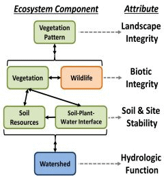 AIM-Monitoring follows a structured implementation framework built on management questions and conceptual models of ecosystem structure and function. The framework consists of multiple steps. Each effort begins by collecting background information, including what is known about the ecosystem, critical management questions, and regulatory requirements. Conceptual models assist with this step by displaying the current understanding of key ecosystem processes. Next, monitoring objectives, indicators, and activities are planned and implemented over the long term. Periodic analysis and reporting of monitoring data inform an iterative process of adaptive management, by which land managers learn from and adjust their management actions. Sound data management, including detailed records, quality assurance/quality control, and data storage in a national geospatial infrastructure, are key components of this framework.
Collectively, AIM-Monitoring information provides a basis for land managers to adaptively manage resources, improve understanding of the ecosystem, and adjust monitoring efforts as necessary using a well-documented and consistent approach.
2. Standard Quantitative Indicators and Methods
Field-based core and contingent indicators (Table 1) address three key attributes of ecosystem sustainability: biotic integrity, soil/site stability, and hydrologic function. These broadly applicable indicators were selected following a nationwide, interdisciplinary review of BLM monitoring efforts and are relevant across resource management programs and ecosystems. A fourth key attribute, landscape integrity, was added because of the importance of spatial landscape characteristics to wildlife habitat needs and ecosystem sustainability. These four key attributes, along with their associated terrestrial and aquatic core indicators, are always measured when an AIM-Monitoring design is deployed, regardless of the program or location of the management area. Contingent and/or supplemental indicators are measured when necessary to address specific local, regional, or national resource needs or objectives.
| Table 1. Core and contingent indicators for the Assessment, Inventory, and Monitoring Strategy and their recommended collection methods. | |||
| Type | Indicator | Method | Where Applied? |
|---|---|---|---|
| Core | Amount of bare ground | Line-point intercept supplemented with plot-level species inventory | All vegetation monitoring |
| Vegetation composition | |||
| Nonnative invasive species | |||
| Plant species of management concern | |||
| Vegetation height | Height at selected line-point intercept points | All vegetation monitoring | |
| Proportion of site in large, intercanopy gaps | Canopy gap intercept | All vegetation monitoring | |
| Contingent | Soil aggregate stability | Soil stability test | When soils are potentially unstable (most rangelands) |
| Significant accumulation of toxins | Sampling for toxins in soil | When toxins are believed to be present (e.g., chemical spills) | |
AIM-Monitoring establishes standardized methods for collecting data necessary to derive the core and contingent indicators of ecosystem sustainability. The benefits of the selected core and contingent monitoring methods are that they are objective, repeatable with minimal observer bias, easy to implement, well documented, and widely used. Further, these methods reflect the knowledge and experience of scientists, rangeland managers, and ecologists from many different agencies and institutions.
3. Scalable Sampling Design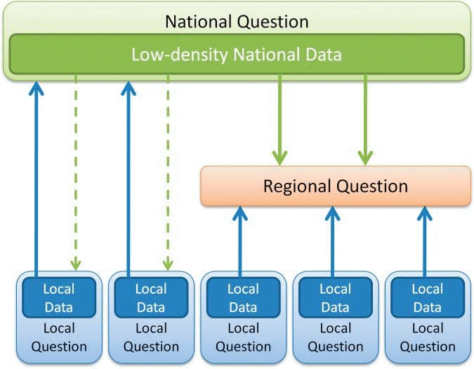
AIM-Monitoring indicators inform management questions at multiple scales. A scalable monitoring design allows the collection of information by local resource managers to meet local management needs or to address broader, landscape-scale, and national reporting needs by combining the data with data collected elsewhere. Scalability requires not only consistent indicators and methods but also a probability-based sample design with a known inference space.
4. Integration of Remote Sensing Monitoring Technologies
 The AIM Strategy and AIM-Monitoring emphasize the importance of using remote sensing as a monitoring tool to improve monitoring efficiency. Field data provide precise, probability-based measurements of resource status and trend with a known inference space. By taking advantage of advances in remote sensing science, traditional renewable resource measurements (consistent with AIM core indicators) can be collected using very-high-resolution, three-dimensional remote sensing imagery. Optimizing the integration of field and remote efforts reduces the number of field samples needed to detect resource changes, focuses data collection efforts in areas experiencing high levels of change, and collects data in isolated locations that are difficult to access.
5. Data Management
The AIM Strategy implements standard data collection and storage so that information is readily accessed, aggregated, and shared. This is accomplished through electronic, onsite data capture and centralized data management through BLM's national geospatial infrastructure.
AIM-Monitoring Deployment Goals
A fundamental tenet of AIM-Monitoring is that information can be collected once and used many times for many purposes across many programs (e.g., recreation, grazing, energy, wildlife, and wild horse and burro management). Furthermore, it is easy to compare and combine these data to simultaneously address a wide range of local, regional, and national management needs. All AIM-Monitoring deployments are intended to achieve five goals determined to be important to land managers, from field to national levels, including:
-
Determine the status, condition, and trend of priority resources and key ecosystem components and processes.
-
Determine the location, amount, and spatial pattern of priority resources, key ecosystem components and processes, disturbances, and other changes on the landscape.
-
Provide a conceptual understanding of key ecosystem components, processes, and sustainability concepts that should be incorporated into land use plans, National Environmental Policy Act (NEPA) documents, cumulative effects analyses, etc.
-
Generate quantitative and spatial data to address goals 1 and 2 and to contribute to existing land health assessment and evaluation processes at multiple scales of inquiry.
-
Generate quantitative and spatial data that are necessary to defensibly determine if management actions (e.g., land treatments) are moving resources toward desired states, conditions, or specific resource objectives identified in planning or related documents or legal mandates.
Interpreting Measures: Using Monitoring Data to Determine Land Condition
Interpreting the status, condition, or rate of change of renewable resources to determine land condition requires comparison of data collected via field sampling and/or remote sensing against indicators of ecological attributes for desired conditions. Desired conditions are based on an understanding of site and landscape potential and represent targets for land management.
Ecological site descriptions (ESDs) are one resource that describe the potential of a site to support different types and amounts of vegetation, determined by factors like soils, climate, and landform. ESDs are the basic units for stratifying landscapes for site-level AIM-Monitoring efforts and are also fundamental for most terrestrial upland land health standards and land health evaluations in the BLM.
Putting AIM-Monitoring into Practice
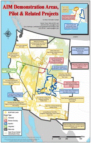
Due to the cross-program, cross-ecosystem relevance of AIM core indicators and methods, AIM-Monitoring is ideally suited for nationwide monitoring efforts. AIM-Monitoring is being implemented across BLM lands through the Landscape Monitoring Framework (LMF), in cooperation with the Natural Resources Conservation Service and Iowa State University. This effort has three functions: providing probability-based estimates of regional rangeland resource conditions, ensuring that all BLM-managed rangelands are covered by a monitoring program, and improving the accuracy of national vegetation mapping. LMF was first deployed in 2011 and is a low-intensity sampling effort, involving the collection of approximately 2,000 sample plots per year across BLM-managed public lands.
AIM-Monitoring can also be rapidly deployed to meet emerging management needs. Such is the case with the BLM’s management of greater sage-grouse habitats. Working in conjunction with the Natural Resources Conservation Service, the BLM is increasing the sampling density of the LMF across the range of the greater sage-grouse to increase the understanding of the status, condition, and trend of these habitats. Importantly, these data are not limited to sage-grouse use in the future. These same data can be used for other wildlife habitat questions and also for recreation, grazing, and climate change effects, to name a few.
Field office deployments of AIM-Monitoring for both aquatic and terrestrial ecosystems are underway. These projects include renewable energy, conventional energy, grazing, sage-grouse, wild horse and burro, postfire restoration, and National Conservation Lands management areas in multiple states. AIM-Monitoring is also being implemented on landscape-scale projects in Alaska, California, and Nevada.
Contacts for AIM-Monitoring
Emily Kachergis
Landscape Ecologist and AIM-Monitoring Implementation Lead
BLM National Operations Center
ekachergis@blm.gov
(303) 236-0071
Gordon Toevs
National AIM Coordinator
BLM Washington Office
gtoevs@blm.gov
(202) 912-7202